Downton Heritage Trail
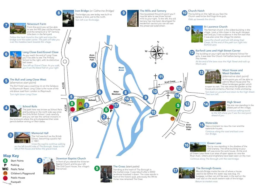
The Downton Heritage Trail is a walking route that takes you through the history of Downton, a village in Wiltshire. It was set up back in 2011 to let people explore the area’s past, and it’s got support from a free leaflet plus a more detailed guide book.
Right now, they’re working on updates like a new leaflet and this website to go with it. The trail highlights spots like St Laurence Church and The Moot, giving visitors a chance to wander and learn about the village’s story.
As for the sites along the way, there are quite a few points of interest, each with its own bit of history. Here’s a rundown:
- The Borough Cross sits at the centre of The Borough; it’s a market cross that got rebuilt after a World War II landmine knocked it down, and it’s in front of a historic pub that used to be called the White Horse but is now The Goat.
- Downton Baptist Church is a Victorian spot nearby, with The Old Court House next to it, which was the village’s first school.
- The Memorial Hall started out as the British School and turned into a public hall in 1887.
- School Rails refers to a path where the building on one side was the Girls’ British School, and you can see marks in the bricks from where girls sharpened their slate pencils.
- The Bull and Long Close West includes The Bull Hotel, an old coaching inn on the road from Salisbury to Weymouth, and Long Close was part of a drove road from London to Weymouth.
- Long Close East and Gravel Close has the primary school with its bell tower, plus the Old Baptist Chapel close by.
- Newcourt Farm is a farmhouse that’s been around for centuries, with bits of a much older tithe barn in the yard.
- Iron Bridge, also known as Catherine Bridge, replaced an earlier ford in the water meadows.
- The Mills and the Tannery area shows former mills and an old tannery that’s now homes, but it still has a waterwheel.
- Church Hatch has a building that was once the Kings Arms pub.
- St Laurence Church is the oldest building in the village, a Norman church, and part of it used to be the fire station.
- Barford Lane and High Street Corner features what was the National School for girls, later a church hall, now turned into houses.
- Moot House and The Moot is at the end of Moot Lane, with a landscape garden you can visit, including a Norman motte and bailey.
- High Street is the oldest part of the village.
- Waterside gives views of the river and houses there, reached via Tannery bridge.
- Green Lane includes the Old Granary and a white building that was the workhouse; at the end, there’s open space by the River Avon where you might spot otters or kingfishers.
- The Borough Greens marks where a house once stood before a waterway was added, with a burgage number in the river wall.
- The Water Meadows path shows old channels for farming, and it’s a site of special scientific interest with wildlife along the river.
Official Website: https://www.downtonheritagetrail.org.uk/